|
|
 for Legal Land Converter")
|

Plot Land |

Search Edmonton Property |
 Android |

Links |
|
Cowichan Land Ruling |
|
Live CSRD Property Query with Boundaries plotted on Latest MapBox Imagery |
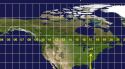
Map of North America with Latitude and Longitude Grid

Map of Canada, the United States and Mexico showing Latitude and Longitude Lines